Home
Home
About Geosun
About Geosun
Products
Products
- Hardware
- Mobile LiDAR Scanning System
- gCollector Road Information Collection System
- gSpin POS System
- PPK Solution
Support
Support
News
News
Contact Us
Contact Us
Airborne LiDAR in smart mining Application

With the introduction of the concept of digital mines, the demand for spatial 3D information in mine management has gradually increased. The management mode of 3D visualization has become one of the main contents of digital mines. However, the data obtained by the current measurement methods are difficult to meet the needs of three-dimensional digital mines. The application of 3D laser scanning technology to obtain spatial 3D information of the complex surfaces and high-altitude areas of mines provides new technical means for solving complex mine measurement and constructing digital mines.
For large-scale open-pit mines, traditional measurements often utilize RTK (Real-Time Kinematic) surveying methods, which offer high precision but are time-consuming and inefficient.
The measurement team requires frequent acquisition of terrain data to promptly assess the volume of filling and detect any unauthorized over-excavation activities. To alleviate the workload of field operations and obtain firsthand information about the mining area promptly, an airborne LiDAR measurement system is undoubtedly the optimal solution for surveying in open-pit mines.
The pre-operation application of airborne LiDAR in mining
Mining Area Digital Modeling
Using drones and LiDAR technology to rapidly acquire three-dimensional information of mines, establishing a digital model based on mine information, providing data support for mine planning, exploration and construction, production and operation management, as well as mine decommissioning, etc.
Simultaneously, targeting open-pit mine slopes, tailings ponds, and surface subsidence in mined-out areas, achieve full coverage, real-time monitoring, and precise early warning to assist mining enterprises in comprehensively enhancing safety supervision levels, reducing mining risks, and realizing safe, green, and sustainable development throughout the entire lifecycle of the mine.

Geological Exploration of Mining
In the geological field, applications of geological surveying can be conducted, including geological mapping, exploration engineering geological surveying, and sampling recording. LiDAR scanners can be used in geological mapping to create geological mineral maps, engineering geological maps, bedrock geological maps, quaternary geological maps, etc. They can replace some of the labor-intensive work of traditional total station surveys. By using airborne LiDAR scanning systems to scan the topography and geomorphology of mining areas and establish databases, subsequent engineering design, layout arrangements, etc., can be completed indoors without the need for on-site surveying, which can improve work efficiency and save manpower resources.
Measurement of High Steep Slopes
In geological survey work, the attitude of structural surfaces is the most fundamental geological parameter. However, the attitude of on-site structural surfaces, especially large faults, often varies significantly, or due to certain terrain factors, it is difficult to directly measure the attitude of some important structural surfaces at close range. These situations all pose challenges to obtaining accurate attitudes of structural surfaces.
The airborne LiDAR scanning system provides an effective solution to this problem. The processing software of the airborne LiDAR scanning system directly offers tools for attitude measurement. By utilizing the fitting plane tool generated in the software, geological structural surfaces can be simulated, and their attitudes can be calculated. This overcomes the shortcomings of single-point attitude measurement with geological compasses and achieves extremely ideal results.
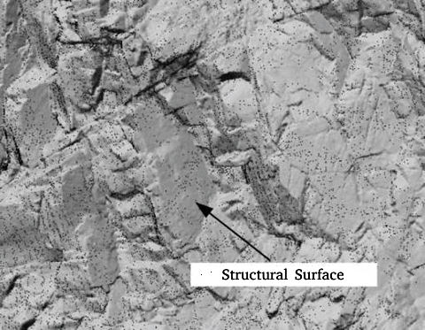
▲ Scan the Raw Point Cloud to Form a Model

▲ Selected Structural Surfaces

▲ Parametric Equations of the Structural Surface
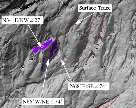
▲ Structural Attitude Survey in Point Cloud Data
The application of airborne LiDAR in mining operations
Measurement and calculation of mining excavation and reserves
Using DEM and DTM data generated from point cloud data, mining excavation measurements can be conducted. Prior to mining, DEM and DTM data can be utilized to calculate the area occupied by vegetation and the volume of earth and rock. The most convenient aspect is the ability to achieve intuitive calculation of mineral reserves. During the mining process, precise spatial information of the void area can be obtained, providing a technical basis for safe production.
Advantage:Streamlining and enhancing the accuracy of open-pit mining volume calculations.
Monitoring of Deep and Cross-border Mining Excavation
By establishing a model of the planned mining face as the boundary for mining depth and scope, and conducting real-time scans of the mining face using LiDAR during the extraction process, comparisons can be made with the planned mining face. If the depth or scope exceeds the plan, it will be highlighted in the data to indicate deviation, allowing for timely warning of boundary infringements during mining.
Obtaining Digital Line Drawings
The digital terrain model with a 1-meter resolution, established from the mining extraction model, can generate high-precision contour maps. By stitching together high-density, high-precision point cloud models through modeling, digital line drawings ranging from 1:500 to 1:5000 will be provided for the mine. This achieves the acquisition of basic survey data for the mine.

Advantages:
1. enches, fan drifts, etc.) can be obtained through one-time scanning, capturing the spatial positions of multiple facilities. The data is visually intuitive, facilitating the establishment of models. After vectorization, it can be integrated as topographic elements into the mining topographic map.
2. Open-pit mining surveying enables rapid measurement, high-resolution contour mapping, and high-quality data, as shown in the image below:

▲ Contour Map
Analysis of Bench Thickness
By overlaying the 3D models of the same mine dump from different stages, such as comparing the dump from two consecutive days, one can obtain the thickness of the operating face and assess the settlement situation for each day.
Geological Hazard Early Warning in Mining Areas
Mining geological hazards not only directly affect the geological environment of the mine but also pose a serious threat to human safety. Therefore, monitoring and early warning of the mining geological environment are crucial.
By combining methods such as three-dimensional laser scanning and GNSS monitoring, static monitoring and periodic scanning are conducted in the mining area. Modeling and analysis of the terrain and landforms in the mining area are performed to assess the trends in terrain subsidence, landform displacement, and slope changes. This approach enables the observation of surface displacement and deformation development of landslides, collapses, and unstable slopes.

The application of airborne LiDAR in mining areas after operations
Ecological restoration measurement in mining areas
The types of mines can be divided into ecological restoration of subsidence areas, mine pits, and slag heaps; ecological restoration of slopes can be categorized into road slopes and riverbank slopes. Developed countries began work on ecological restoration of quarries in the early last century, with initial research focusing on vegetation restoration of abandoned land left after mining.
By scanning and modeling the terrain and environment of the mining area using LiDAR, we can understand the overall situation of the mining area for discussion and analysis. This enables us to plan and layout the rational restoration and governance of abandoned mining areas. The goal is to achieve a sustainable development where the relationship between plants and humans is emphasized, and humans rely on plants. This approach can showcase the original landscape pattern of the mining area, integrating natural architecture and blending two types of vegetation - garden landscapes and ecological landscapes - seamlessly.


