Home
Home
About Geosun
About Geosun
Products
Products
- Hardware
- Mobile LiDAR Scanning System
- gCollector Road Information Collection System
- gSpin POS System
- PPK Solution
Support
Support
News
News
Contact Us
Contact Us
Background
In the face of already established power transmission lines, effective inspections are necessary to ensure electrical safety. Traditional manual inspection methods not only involve large workloads but also harsh conditions, especially when inspecting transmission lines in mountainous areas or spanning major rivers. The combination of drones and LiDAR (Light Detection and Ranging) technology can significantly enhance the speed and efficiency of power transmission maintenance and inspection. Many tasks can be swiftly completed through the exclusive use of drones and LiDAR scanning system which is safe, fast, efficient, and intelligent approach to line inspection.

In this project, the power transmission lines are dispersed throughout the hilly terrain of Chongqing municipality, with most lines passing through roadless mountainous regions where personnel access is difficult. The client requires a short project duration and the submission of classified point cloud results and reports analyzing the line corridors. Fine-tuned inspection tasks will be conducted based on point cloud data in the later stages of the project.
Difficulties
The project has a tight deadline, with a total transmission line length of 170 km, and the client requires scanning and output of results within 7 days.
The lines are dispersed, making airspace coordination challenging, with significant elevation differences and some lines passing through dense forests.
Additionally, the lines intersect with varying complexity levels.
Project Solution

The project utilizes our gAirHawk GS-100C+ scanning system mounted on the DJI M300 drone. The GS-100C+ weighs only 1kg, maximizing operational duration. Multiple teams will collaborate, employing a base station-free mode.
High-frequency point capture ensures the comprehensive and effective collection of line data. Data transmission and synchronous processing enable the batch output of classified point clouds and analysis reports.
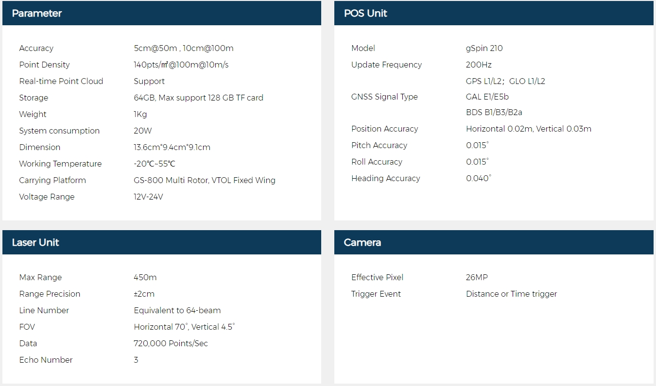
Hardware Introduction

GS-100C
The GS-100C+ is a lightweight and compact short-range unmanned aerial vehicle LiDAR system developed by Geosun Navigation. It features three return echoes, enabling real-time, dynamic, and massive collection of high-precision point cloud data and rich image information. It is widely used in industries such as terrain mapping and power line inspection.
Flight Route Planning
Use DJI Phantom 4 RTK or M300 RTK drone to position the gimbal directly above the tower and take photos of the tower top.
Field Point Cloud Collection
General Setting
Basic Flight Safety Settings
1. Return altitude (above obstacles: 30 meters)
2. Drone loss of control return (for larger survey areas, if the flight path safety is ensured, the option to continue the route despite loss of control can be selected)
3. Intelligent low battery return
Base Station Setting
1. Set up the base station in an open area within 30 kilometers of the survey area
2. Set the RTK base station to static mode, with a frequency of 1Hz, and a height cutoff angle of 10° or 5°
3. Measure the latitude and longitude coordinates of the base station installation site, and measure the antenna height (measured to the phase center)
Radar Setting
1. Install the GNSS antenna and connect it to the antenna interface
2. After the device is powered on, when the GNSS light starts flashing at 1-second intervals, wait for 5 minutes before proceeding with the flight
3. You can take off once the camera-equipped device starts taking photos
After the static phase ends, check whether the drone and radar indicator lights are functioning properly. Upload the flight path and begin execution. At the start of the flight path, the drone must maneuver in a figure-eight pattern. When the flight path ends, the drone should return directly and power down. This concludes the outdoor data collection. Upon return, there is no need to maneuver in a figure-eight pattern or enter a static phase.
Data Export
Remove the SD card and insert it into the computer using a card reader for copying.
Point Cloud Data Preprocessing
Importing the base station, rover station, raw LiDAR files, and photo storage folder in sequence, the gAirHawk software automatically reads the device parameters and synchronizes the trajectory and color point cloud for one-click processing.
View Point Cloud
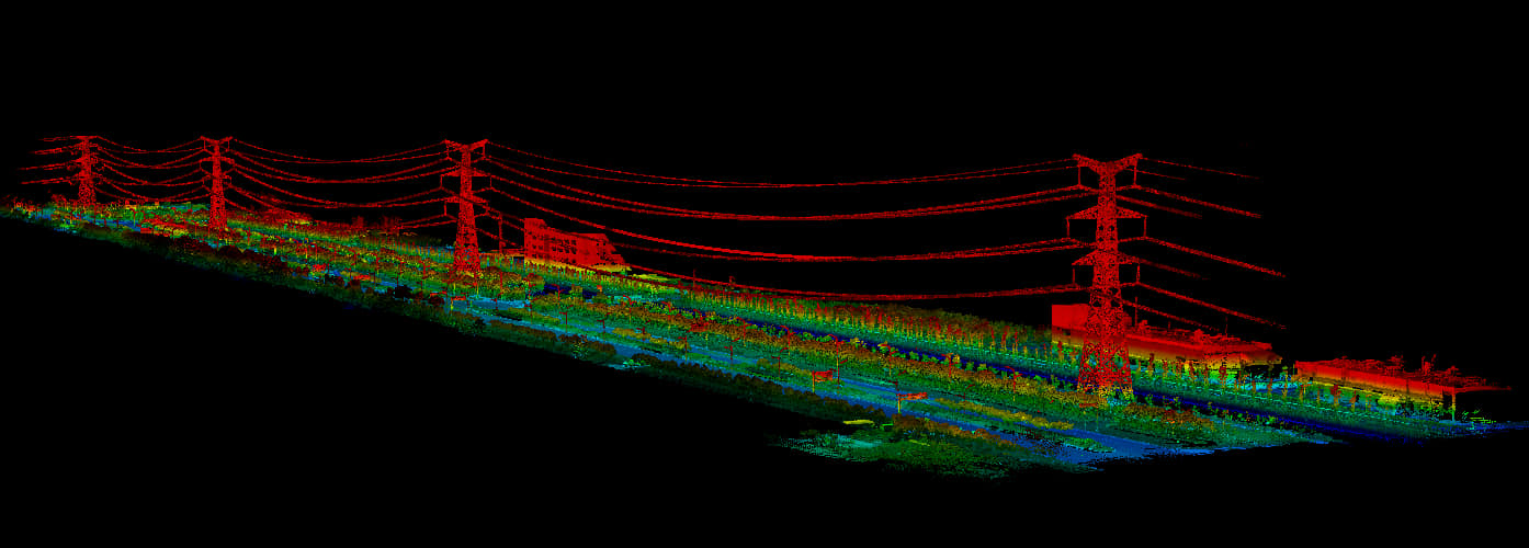
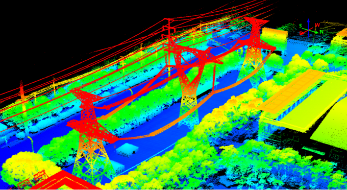
Point Cloud Classification
Automatic Point Cloud Classification and Interactive Point Cloud Classification
The processes are standardized and streamlined, suitable for different voltage levels and terrains, with classification accuracy exceeding 95%. It can automatically classify ground, low vegetation, high vegetation, poles, conductors, and ground wires, and also allows for manual interaction when necessary.
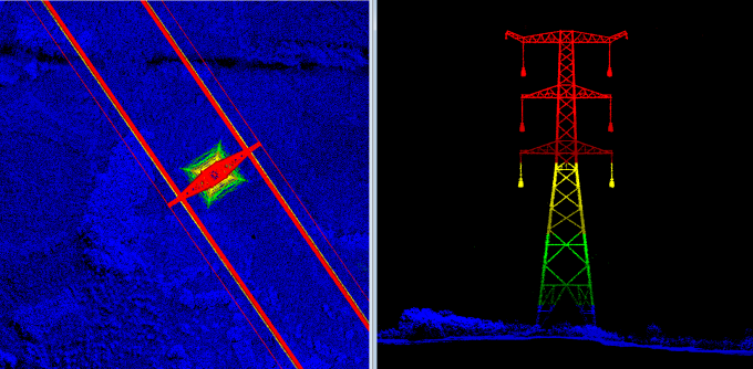
Real-time Operational Safety Distance Detection Report
According to the "Overhead Transmission Line Operation Regulations (DL/T 741-2019)", based on LiDAR point cloud data, automatic star measurements are conducted between transmission conductors, conductors and ground, slopes, buildings, trees, crossings with other power lines, communication lines, transportation facilities, and other line and pipeline spacings. This process forms a real-time operational safety distance detection report.
Support Simulation Condition Analysis and Automatically Generate Analysis Report.
Simulate changes in conductor wind deflection and sag under conditions of strong winds, high temperatures, and icing. Combining three-dimensional terrain and models, conduct clearance distance checks for safe operation of the power line, and generate reports.
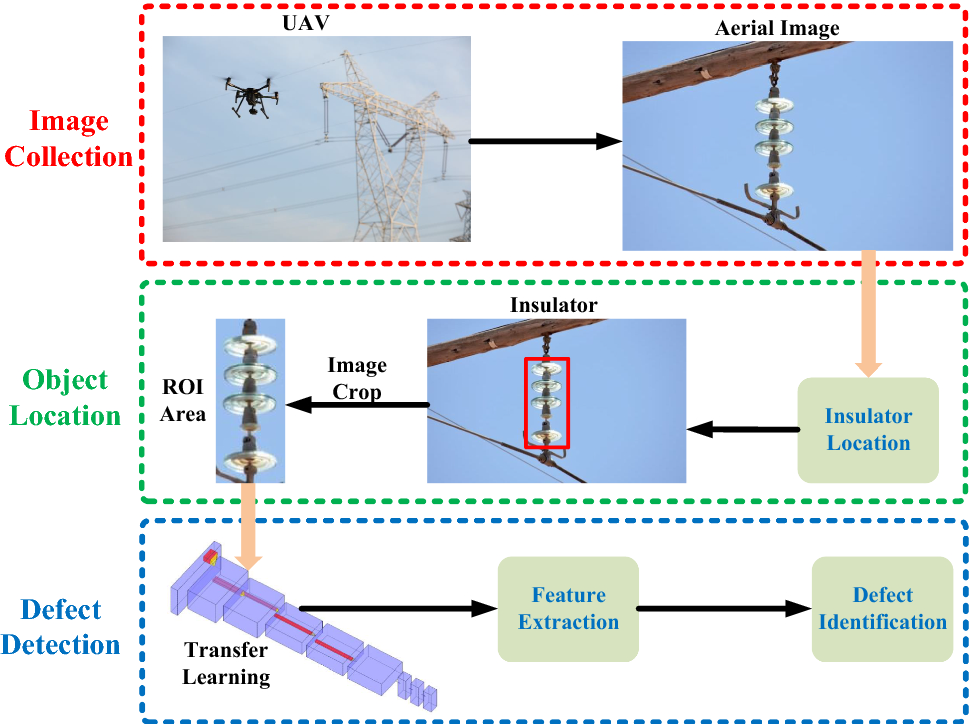
Defect Identification System
The defect recognition system utilizes machine deep learning and artificial intelligence algorithms based on power-related specifications and equipment defect sample libraries. This system automatically identifies defects in inspection images according to corresponding defect categories. It liberates inspectors from the heavy burden of manual identification work, greatly improving work efficiency.
The defect library system categorizes components such as conductors, insulators, vibration dampers, and heavy hammer pieces based on different weather conditions such as sunny, cloudy, and snowy. It annotates them according to labeling rules and constructs a dataset of transmission line images.
Conclusion
Laser scanning technology enables high-precision reconstruction of power lines and corridors, automatically measuring distances from objects to power lines, and providing early warning for hazardous points. It can be widely applied in areas such as optimizing power line routes and optimizing pole placement. This technology facilitates the digitization of surveying, design, and construction results, as well as provides data support for three-dimensional visualization management and professional analysis of power lines.
Our solution possesses the following advantages:
1. Low cost: The solution incurs low costs in terms of construction, maintenance, and manpower utilization
2. High efficiency: The solution enables one-click processing, rapid generation of point cloud data, and round-the-clock task execution, resulting in higher efficiency compared to traditional manual line inspection methods
3. High safety: It ensures high levels of safety by avoiding placing line inspectors in high-risk working environments
4. Lightweight and portable: The solution is easy to carry, simple to operate, responsive, and requires minimal environmental requirements for takeoff and landing.
5. Our owning proprietary POS system greatly reduces the cost of unmanned aerial vehicle (UAV) laser scanning systems. The POS system is mature and stable, supporting applications of low, medium, and high precision.
6. GNSS Signal Support: The system supports BeiDou-3 signals and pure BeiDou positioning solutions, which are particularly crucial for military and government departments.
7. Having a complete end-to-end solution, with convenient and fast post-processing, and high automation.
8. Independently developed Pre-processing software with lifetime free access.


