Home
Home
About Geosun
About Geosun
Products
Products
- Hardware
- Mobile LiDAR Scanning System
- gCollector Road Information Collection System
- gSpin POS System
- PPK Solution
Support
Support
News
News
Contact Us
Contact Us
Background
To pragmatically advance the top-level design of "Shared China Petrochemicals" and achieve digital transformation and intelligent development, China Petrochemical Corporation focuses on the overall goal of integrating informatization and industrialization. It closely integrates its main business and strives to build digital oil and gas fields characterized by "standardized positions, standardized territories, digitized management, automated production, digitized office, and intelligent management.

Advantages
The comprehensive digitization of oil and gas fields has seen breakthrough improvements in management and construction.
1. In terms of operations management, it enables convenient new employee training and daily status query surveys
2. In terms of asset management, it enables precise equipment design, statistical backup, and visualization-based classification management. It facilitates convenient and accurate equipment status queries.
3. In terms of safety management, it enables easy implementation of intelligent inspections, real-time safety checks, emergency plan simulations, and analysis of deformations in large equipment (such as tanks and pipelines). It allows for timely, rapid, effective, and intuitive emergency measures to be taken in case of accidents.
4. In oil field construction, it enables 1:1 replication and relocation. During the renovation process, it assists in design based on three-dimensional models, and during installation, it enables simulated collision analysis, making expansion and renovation more precise and convenient.
Project Solution
For this task, we have chosen the combination of the DJI M300 RTK and Geosun GS-130X scanning system. The GS-130X features a 360° field of view, enabling complete scanning of buildings and providing convenience for subsequent point cloud data processing. Additionally, the GS-100G handheld laser scanning system can acquire point cloud data in indoor environments, underground spaces, densely packed pipelines, and pipeline corridors.

Products
Based on a thorough understanding of the project, we have decided to use the Geosun gAirHawk GS-260X LiDAR system for this task. The gAirHawk GS-260X is a lightweight, medium-range airborne radar system independently developed by Jiushang Navigation. It features a 360° field of view, three returns, and integrates optical cameras, allowing it to capture image data simultaneously.

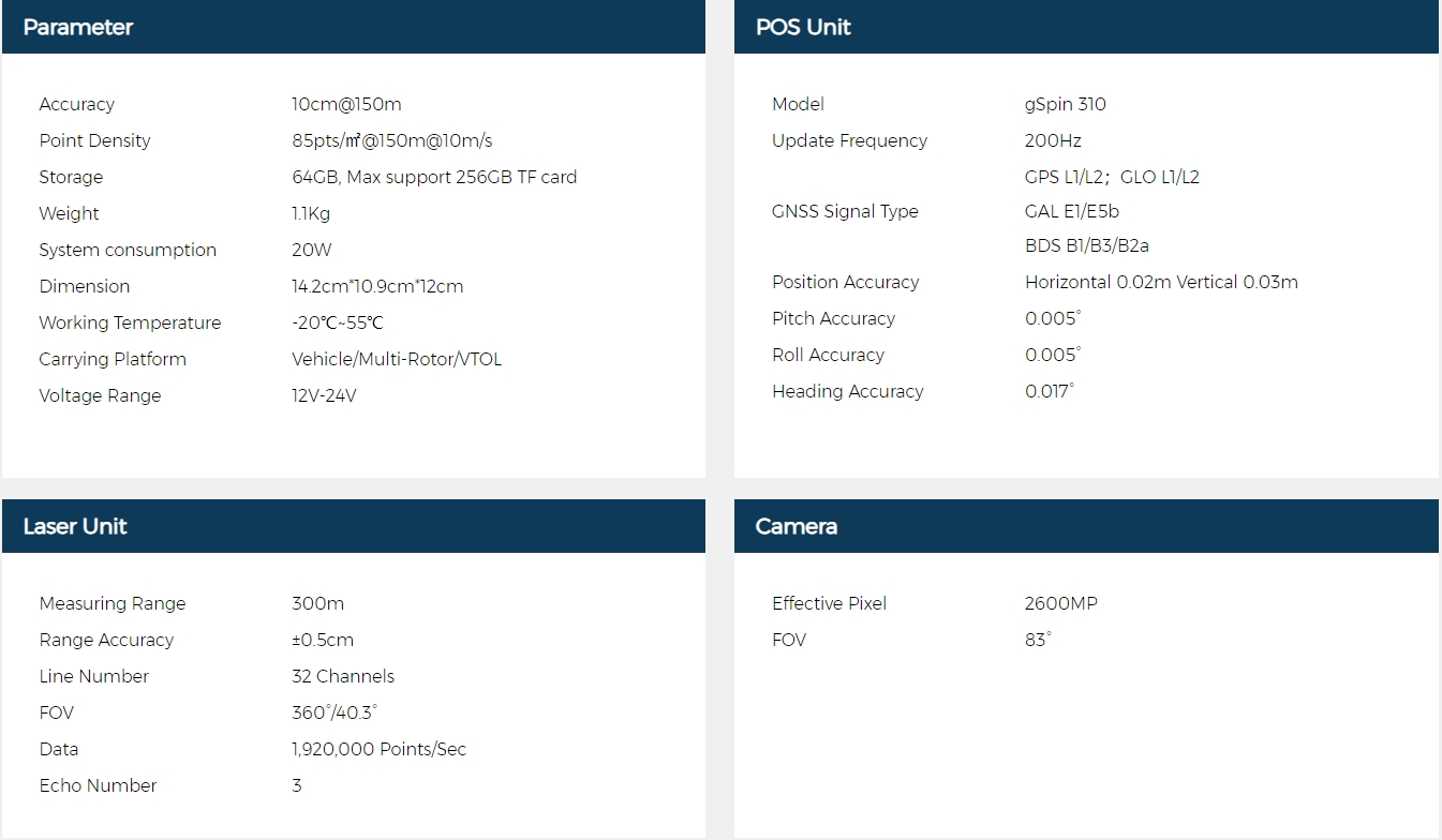
GS-260X
GS-260X Specification:
GS-100G is a portable handheld mobile LiDAR scanner launched by Jiushang Navigation. The system features a 360° rotating gimbal, capable of generating 270° x 360° point cloud coverage. Combined with industry-standard SLAM algorithms, it seamlessly captures three-dimensional point cloud data of the surrounding environment, whether GNSS-enabled or not.

GS-100G
GS-100G Specification:

Results

Point Cloud 1:1 Modeling


Indoor Equipment Modeling

Indoor Equipment Modeling

Indoor Equipment Modeling


