Home
Home
About Geosun
About Geosun
Products
Products
- Hardware
- Mobile LiDAR Scanning System
- gCollector Road Information Collection System
- gSpin POS System
- PPK Solution
Support
Support
News
News
Contact Us
Contact Us
Background
In the traditional technical mode, reservoir exploration work is mainly completed using CAD. However, CAD operates on a two-dimensional plane, which has limitations in expressing information and can lead to cumbersome and less intuitive design processes. Therefore, there are certain deficiencies in practical applications. On the other hand, three-dimensional data models offer advantages such as rich information, intuitive operation, and high modeling efficiency.

Solution
For this task, we have chosen the combination of the DJI M300 RTK, GS-260X LiDAR scanning system, and GNSS deformation monitoring system. The GS-260X supports three returns, effectively penetrating vegetation to obtain ground point data, which greatly facilitates subsequent point cloud data processing. As the survey area is located in a reservoir area with significant terrain variations, we have opted to use WPM (WaypointMaster) for the flight route planning task. WPM flight planning automatically adds intermediate calibration routes in long-distance constant-speed straight flight routes of LiDAR scanning, avoiding the problem of decreased absolute accuracy due to inertial navigation drift.
Product
Based on a thorough understanding of the project, we have decided to adopt the Geosun GS-260X LiDAR scanning system. The GS-260X has a maximum range of 300m, weighs only 0.99kg, maximizing operational duration. It has a maximum laser point frequency of 1,920,000 points per second, supports three returns, and has strong penetration capabilities. Additionally, it integrates a camera deeply, enabling synchronized acquisition of point clouds and images. The GS-260X is widely used in industries such as topographic mapping, water conservancy, power line inspection, forestry surveys, and digital cities, making large-scale data acquisition more convenient.


Advantages:
Modularity: Easy installation, rapid deployment, compatibility with mainstream drones on the market
Base station-free operation: No need to set up physical base stations, with data accuracy better than 1:1000 large-scale maps
Fully autonomous: Integrated power supply, one-key takeoff, automatic data collection, one-key data download, capable of being operated by a single person
True color directly: Achieve true colorization of LiDAR point clouds without the need for aerial triangulation
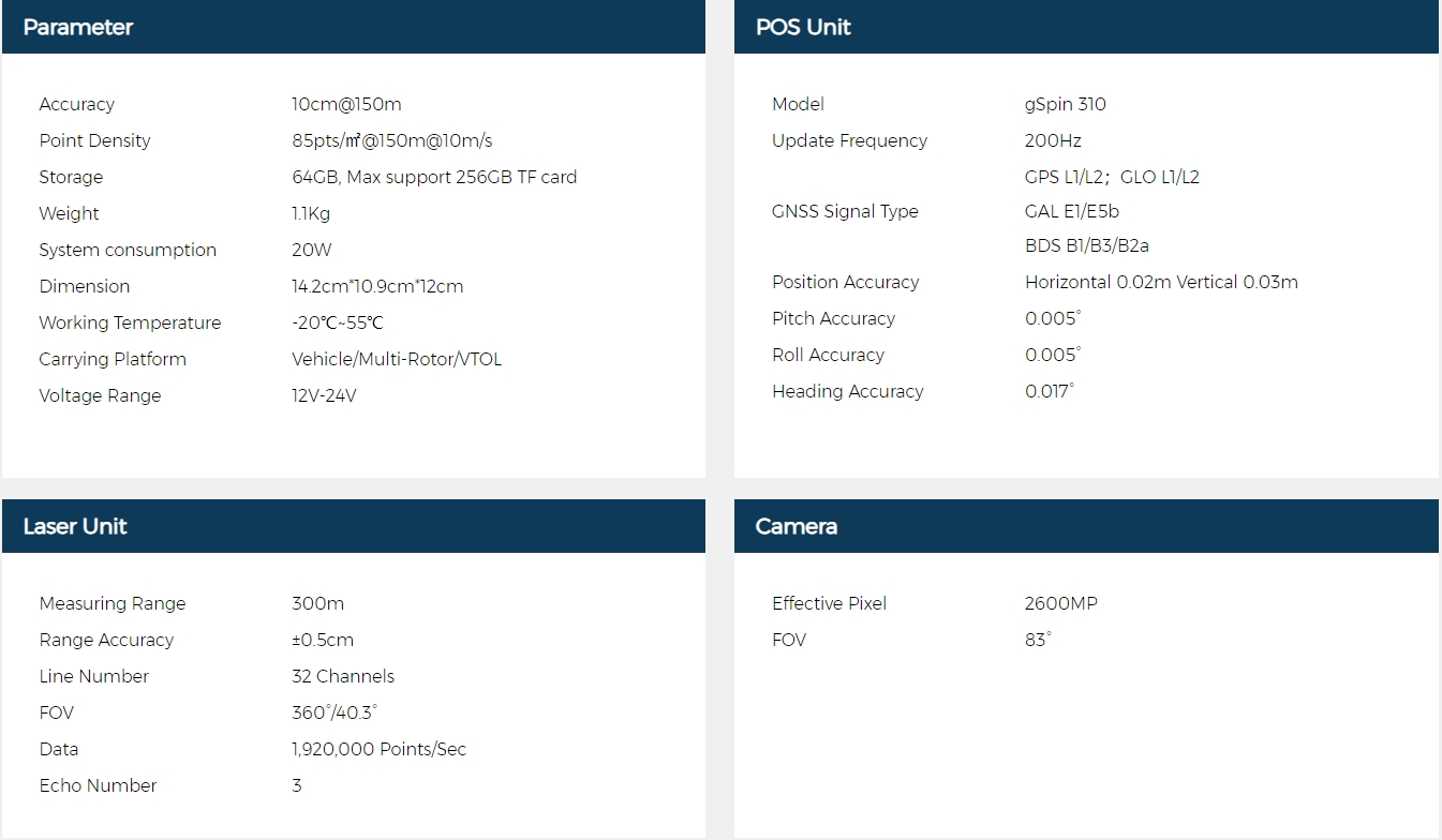
GS-260X Specification:
Field Operation
After determining the trial equipment, it is necessary to establish the parameters of the LiDAR. In the parameter planning process, various factors must be comprehensively considered, including the image's forward and side overlap, ground resolution, LiDAR scanning frequency, side overlap rate, line scanning speed, point density, UAV flight speed, and other factors.
1. Flight Path Planning
Flight path planning is a critical factor in determining the quality of flight scanning, measurement, and imaging tasks. The design of flight paths needs to comprehensively consider factors such as terrain, endurance, and the area of the survey area, and reasonably divide flight segments and set overlap levels. It also requires on-site reconnaissance to select take-off points, preferably in areas with open views and minimal signal interference. We use a customized version of WPM software, where inputting the flight altitude and overlap rate automatically plans the flight path, making it convenient and efficient. This software also ensures flight safety, avoiding drone accidents caused by terrain fluctuations, thereby improving field efficiency and safety.
2. Flight Operation
After the LiDAR is stationary for 3 minutes, uploading and executing the flight path will automatically complete the field data collection.
3. Data Collection

Performing flight scanning, measurement, and imaging for hydraulic engineering using the method of importing planned flight paths via the remote controller and executing them, allowing for automatic data collection by the LiDAR. This process yields high-precision point cloud and image data.
4. Data Processing
Importing the base station, rover station, raw LiDAR files, and photo storage folder in sequence, the gAirHawk software automatically reads the device parameters and synchronizes the trajectory and color point cloud for one-click processing.
5. Result


Conclusion
Technical Advantages: Addressing the common operational environments in water conservancy and hydropower and the characteristics of LiDAR point cloud data, the airborne LiDAR technology, combined with traditional photogrammetry, is particularly effective in terrain mapping applications in densely vegetated areas. This includes the classification of LiDAR point cloud data, covering every step from data acquisition, preprocessing, point cloud filtering and classification, aerial triangulation, to mapping, enabling the extraction and mapping of ground information in densely vegetated areas. Airborne LiDAR scanning systems have significant advantages in measuring complex and vegetated areas, indicating promising applications in the field of water conservancy and hydropower engineering surveying in the future.


