Home
Home
About Geosun
About Geosun
Products
Products
- Hardware
- Mobile LiDAR Scanning System
- gCollector Road Information Collection System
- gSpin POS System
- PPK Solution
Support
Support
News
News
Contact Us
Contact Us

Simultaneous Localization and Mapping (SLAM) is the crucial technology driving mobile mapping systems, enabling them to function without a stationary tripod. By dynamically tracking the device’s position in real-time, SLAM ensures accurate, high-quality spatial data collection, even in complex and large-scale environments.

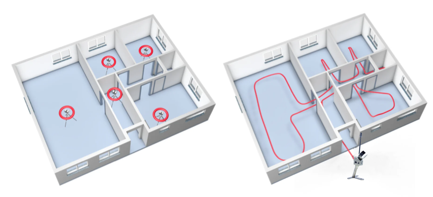
SLAM technology integrates data from multiple onboard sensors in a mobile mapping system, tracking movement while capturing spatial data. Each point along the path acts as a “virtual tripod,” allowing the system to create highly precise 3D maps. During the post-processing stage, the software aligns this data into accurate point clouds, which provide detailed representations of the environment.
By removing the need for multiple fixed setups, SLAM allows mobile mapping to collect data continuously, drastically improving the speed and precision of surveying projects.
Building documentation has come a long way, from manual methods like theodolites and tape measures to the modern laser scanning solutions we use today. The 1980s brought total stations, offering enhanced precision, while the 2000s introduced terrestrial laser scanners (TLS), which capture millions of data points at once. However, TLS systems require fixed positions, making the process slow and cumbersome.
SLAM-based mobile mapping systems, which emerged in 2015, have transformed how we document spaces. They allow operators to capture millions of points while moving, significantly reducing setup times. In addition, these systems often feature integrated RGB cameras that capture 360° photography, providing comprehensive, photorealistic visual documentation.
Rapid Data Collection: Traditional TLS workflows require numerous setups in larger projects, slowing progress. In contrast, SLAM-enabled mobile mapping delivers a 10x or greater speed improvement by eliminating these steps and continuously scanning the environment.

Simplified Data Registration: TLS systems require aligning scans via overlaps or targets, which can be time-consuming. Mobile mapping devices with SLAM scan continuously—covering up to 3,000 square meters—before the operator needs to restart, reducing the complexity of data registration.
Complete Coverage: TLS can only capture data within its direct line of sight, often requiring repositioning to avoid gaps. SLAM technology allows operators to simply walk around obstacles, ensuring comprehensive coverage with no blank spots in the point cloud.
Photorealistic 3D Documentation: SLAM-powered mobile mappers integrate LiDAR with RGB cameras, producing dense point clouds and photorealistic 3D models. These intuitive, high-resolution data sets are easy to navigate, even for stakeholders who are not familiar with point cloud technology.
Real-Time Feedback: Many advanced mobile mapping systems provide real-time feedback on data quality through a tablet interface. This ensures that operators can instantly detect and correct missed areas during the capture process, improving workflow efficiency.
SLAM has revolutionized modern surveying and mapping by dramatically improving workflow speed, accuracy, and coverage. Traditional methods like TLS require multiple setups and manual adjustments, while SLAM-based mobile mapping allows seamless, continuous data collection with minimal downtime. The result is a complete, highly accurate, and visually rich 3D dataset that can be generated in a fraction of the time.
In industries such as construction, urban planning, and facility management, where time and precision are critical, SLAM-powered mobile LiDAR systems have become indispensable. The ability to capture detailed 3D maps quickly, even in large and complex environments, makes SLAM technology a cornerstone in the evolution of mapping and building documentation.
URL:https://www.geosuntech.com/News/241.html
Previous:Geosun Navigation Celebrates a Successful Exhibition at INTERGEO 2024


