Home
Home
About Geosun
About Geosun
Products
Products
- Hardware
- Mobile LiDAR Scanning System
- gCollector Road Information Collection System
- gSpin POS System
- PPK Solution
Support
Support
News
News
Contact Us
Contact Us

Today, both LiDAR and Photogrammetry applications are rapidly evolving in the field of drone mapping. With the gradual decrease in drone prices, people can use drone surveying techniques for quick assessments of land and infrastructure. Currently, when it comes to drone mapping tasks, the choice between LiDAR and Photogrammetry imaging largely depends on the specific application at hand, as well as operational factors such as cost and complexity. In this article, we will explore the differences between LiDAR and Photogrammetry technology.
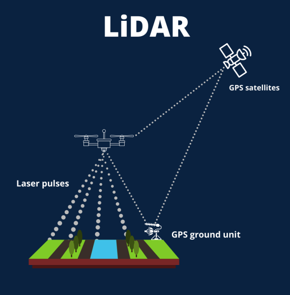
LiDAR stands for "Light Detection and Ranging," and this technology has been around for decades but has recently become available in sizes and power suitable for large drones. A LiDAR sensor emits laser pulses and measures the exact time it takes for these pulses to return after bouncing off the ground, as well as the intensity of the reflections.

The sensor itself is just a part of the LiDAR system, and it is crucial to have a high-precision Global Navigation Satellite System (GNSS) and an Inertial Measurement Unit (IMU) to determine the sensor's orientation in space. All these high-end subsystems must work in perfect coordination to process the raw data into usable information, a process known as direct georeferencing.
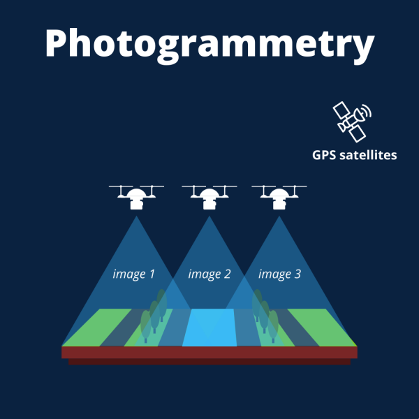
Photogrammetry is a technique that uses images of objects to reconstruct their spatial positions and three-dimensional shapes. In photogrammetry, a drone captures a large number of high-resolution photos in an area, and these images overlap, allowing the same point on the ground to be seen from different advantageous positions and across multiple photos. Similar to how the human brain uses information from two eyes to provide depth perception, photogrammetry utilizes these multiple advantageous positions in the images to generate a 3D map.

Therefore, high-resolution 3D reconstruction includes not only elevation/height information but also the texture, shape, and color of each point on the map, making it easier to interpret the generated 3D point cloud.
LiDAR: LiDAR technology relies on the emission and detection of laser pulses to measure the distance between the sensor and objects in its vicinity. By analyzing the time it takes for the laser pulses to return after bouncing off the target, LiDAR calculates precise distances and creates a point cloud representation of the environment.
Photogrammetry: Photogrammetry, on the other hand, utilizes overlapping images captured from different angles to extract 3D information. By analyzing the parallax effect, which is the apparent shift of objects due to the change in perspective between images, photogrammetry algorithms reconstruct the 3D geometry of the scene.
LiDAR: LiDAR systems emit laser pulses in a scanning pattern, capturing a large number of points per second across a wide field of view. This enables LiDAR to provide dense and accurate point clouds, even in complex environments such as dense vegetation or urban areas.
Photogrammetry: Photogrammetry relies on capturing a series of high-resolution images using cameras mounted on drones, aircraft, or ground-based platforms. These images need to have significant overlap to ensure accurate reconstruction. The quality of the photogrammetric output depends on image resolution, overlap, and the availability of distinct features for matching.
LiDAR: LiDAR systems are known for their high accuracy in measuring distances, typically achieving sub-centimeter precision. LiDAR also provides consistent accuracy across different ranges, making it suitable for applications that require precise measurements.
Photogrammetry: The accuracy of photogrammetry is influenced by various factors, including image quality, camera calibration, GPS accuracy, and the presence of occlusions. While photogrammetry can achieve high accuracy, it is generally considered to have lower accuracy compared to LiDAR. However, advancements in camera technology and image processing algorithms have significantly improved photogrammetric accuracy in recent years.
LiDAR: LiDAR sensors generate dense point clouds with a high point density, providing detailed information about the captured environment. This makes LiDAR ideal for applications such as terrain modeling, forest inventory, and infrastructure monitoring.
Photogrammetry: The point density in photogrammetry depends on the resolution of the captured images and the distance to the objects. While photogrammetry can produce accurate results, it typically has a lower point density compared to LiDAR. However, photogrammetry excels in providing high-resolution textures and colors, making it suitable for visual applications like virtual reality, visual effects, and architectural visualization.
LiDAR: Due to its accurate distance measurements and ability to penetrate vegetation, LiDAR is extensively used in applications such as topographic mapping, flood modeling, autonomous driving, and precision agriculture. LiDAR also finds applications in creating digital elevation models (DEMs), analyzing urban environments, and archaeological site mapping.
Photogrammetry: Photogrammetry has a wide range of applications, including 3D mapping of cultural heritage sites, environmental monitoring, construction site documentation, and landscape modeling. It is also widely used in industries like architecture, film production, gaming, and virtual reality for creating realistic 3D models and visualizations.
URL:https://www.geosuntech.com/News/225.html
Previous:What is SLAM for Handheld LiDAR Scanner?
Next:Industry Trend: Global LiDAR Market Projected to Reach a Value of $11.6 Billion by 2032


